As mentioned in my blog post last Wednesday (blog post on signs of a wet pattern), several key oscillations and global teleconnection signals were pointing to a wet pattern for the Northstate. It now appears that the wet and some what long duration pattern will begin early this coming Friday.
 \
\
This is the current 5 day precipitation total from HPC, forecasted all the way through 4:00 am Monday morning.
You can see that they are currently going with around 2 inches for the valley and around 2-3 inches for the mountains, with a few isolated spots higher than that.

This is the current forecast Pacific North American (PNA forecast info) oscillation teleconnection. As mentioned last Wednesday it is negative and looks to remain negative for the foreseeable future. Typically a strong -PNA reading correlates with a strong blocking high in the North Pacific which allows for long term troughing on the West Coast. With a trough close by that would increase our chances of wet and cold weather.

Currently the Arctic Oscilation (AO forecast info) is Positive but is forecast to soon to turn negative. Typically a -AO corresponds to a weaker Polar Vortex which in turn allows for kinks or trough to swing further south into the lower 48. In general, more troughs and more active weather for the lower 48.

Here is the overall pattern. A typical -PNA setup. Strong blocking high in the North Pacific allows for deep and powerful troughs to slide down to the West Coast.

Initial band of rain forecasted by our in house forecast model. You can see rain moving up from the south around 1:30 am, early Friday morning.

By 10:00 am Friday morning heavier and more widespread rain now over the Northstate.

By 12:30 rain slowly starting to move into the foothills and higher elevations, mainly to the east.

By 4:00 pm you can see a heavy line of rain setting up over the valley floor on late Friday afternoon.

By 7:00 am Saturday morning rain still lingering over the Northstate, mainly the eastern valley, foothills and valley floor.

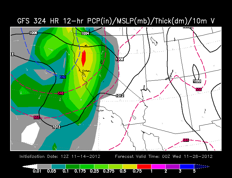
Still having timing issues, but appears our next strong and colder storm will arrive by 4:00 pm next Wednesday.

By 4:00 am Thanksgiving morning heavier rain moves into the Northstate. Snow level look to be around 4000 ft
Even two weeks from today we continue to see the cycle of wet storms rotating through. This is just a trend so do not plan any thing around these maps.
No comments:
Post a Comment