Thursday, December 27, 2012

Quiet Pattern With a Few Weak Systems


After what has been a very active last 30 days we for the most part, take a break.  Every few days or so we will see a weak system that will try to move in, likely dropping  .10" of precip for the valley or less.


Tomorrow's system will hug the coast, split and head south.  Moisture tap will be extremely light so only expecting scattered snow showers in the mountains and a shower or two sneaking down to the valley.


Another weak system will move through Monday.  This is more of a hybrid slider system that will likely bring more wind than rain for most of the Northstate.  The backside of the storm will be a north to south jet axis, that will tighten the surface pressure gradient.  Expect a slight breeze out of the north.


And again another weak system Wednesday evening that will likely hug the coast and dip south.  3 very weak systems that are all starved for moisture over the next 7 days.

After what seemed like an eternity.  the Pacific North American index (teleconnection we look at for blocking in the North Central Pacific) finally went positive after a month and a half negative.  Due to less blocking, big powerful troughs are unable to be nudged down from the Gulf of Alaska to the Northstate.

The Arctic Oscillation continues to push positive and looks to remain positive through the extended period.  AO is a slight measure of how wavy and troughy the jet stream is.  The more negative the more rosby waves can build up on the jet stream, bringing us a better shot at big storms.

And finally the Madden Julian Oscillation continues to be nonexistent.  A very low amplitude wave that is forecasted to meander in the Phase 4/5, which is unfavorable pattern for West Coast storms.  So for now things quiet down.


Wednesday, December 19, 2012

Significant Mountain Snow Event

Though Northern Valley snow still remains a challenge and uncertain, there is certainty that the Northern Shasta, Northern Trinity and Southern Siskiyou mountains will see a tremendous amount of snow.

The image above is the 5-day QPF (Quantitative Precipitation Forecast) from the NWS.  Basically this means if everything that were to fall in the form of liquid or if you converted it to rain this is how much precipitation you could expect.  And as you can see Northern Shasta, Southern Siskiyou county get painted with 7-8" of liquid.  Forecast rain-to-snow ratios are right around 1:11" averaged out for the entire event.  So you're talking 77-88" of snow.  This is likely overdone but fascinating none the less.

As you can see HPC is also leaning between 7-9" of QPF too.

Here is the 72 hour snowfall accumulation map.  Unfortunately it only goes out until 10:00am Saturday.  But right in that bullseye I showed you above you can see where our in-house model is picking up 60-72" of snow in the Mount Shasta City area through Saturday morning, not including the rest of Saturday's or Sunday storm too.

HOW ABOUT THE VALLEY?

This is the million dollar question.  In the last 18 hours, forecast models have drastically slowed down the initial storm.  This will play a major role in the chances for valley snow.  


At 5:00 am Thursday morning there is actually quite the clearing on the forecast Satellite over Redding.  So we could see some decent radiational cooling.

By 8:00am Thursday morning you can see some decent cloud cover has moved over about Red Bluff and North.  So maybe enough cloud cover to lock the cold air in place.

The Biggest challenge of the Forecast is the winds.  We are expecting strong south winds for most of the valley.  IF the winds make it into Redding then our chances for accumulating snow are greatly reduced to near 0.

Here some forecasts of the winds tomorrow morning.
As of 11:30 tomorrow morning the strong south winds are south and southeast of Redding, unable to penetrate the cold air-mass.

The rest of the day the winds try to increase near Redding but still the south winds are not as strong as the winds south and southeast of Redding.


The image above is the Forecast Skew T sounding for Redding at 10:00 am tomorrow morning.  The surface air column is still not fully saturated.  But the 0-degree wet bulb height is 377ft, which means that at that time if enough precipitation were to fall it would be 32 degrees F or 0 degrees C at 377ft elevation.  *****The wet bulb temperature is the temperature the air would fall to at full saturation (through evaporative cooling)  However models continue to show precipitation not moving in until after 12:00pm.


By 1:00pm you can now see that air still not fully Saturated and the 0-degree Wet Bulb temperature has now risen to over 1300 ft.

Just because it is not freezing at the surface (Redding's elevation is between 500-900ft) doesn't mean and can't snow.  Redding this past Saturday saw several hours of snow with a temperature of 34 degrees.  Also if the precipitation is hard enough it can bring the cold air down with it and not have enough time to melt.  So overall it appears that for Redding to see snow the earlier the better, which hasn't been in our favor the last few model runs and we are running out of time.


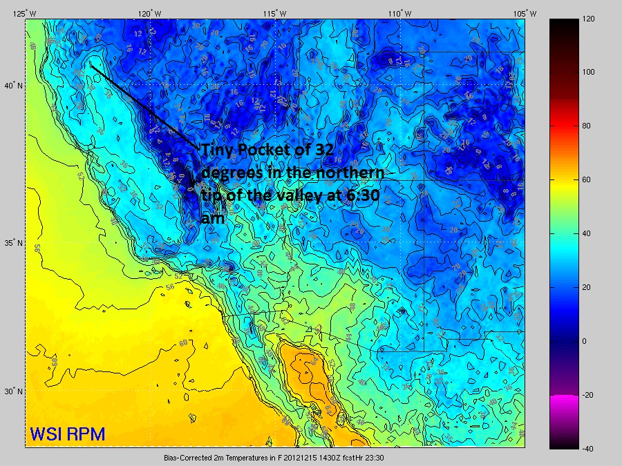
At 8:30 Thursday evening you can see that the rain/snow line is hovering right on or just slightly north of Redding.

That's what makes this forecast so difficult because the rain/snow line is going to hover right over Redding through tomorrow evening, tomorrow night.  Eventually Redding will switch over to rain, washing away any accumulations that we could possibly see.

Stay tuned, things seem to change from one model run to another.


Friday, December 14, 2012

A Look At Snow Chances Saturday

If you have been watching our news over the last 18 hours you have probably seen and heard about very low snow levels by Saturday.  Of all the forecast models we use, our in-house (the one you see on tv) is probably the most aggressive with low snow.

First of all this is a fairly weak system so total precipitation is fairly low.  But for the mountains rain-to-snow ratios will be high so snow can add up with little moisture to work with.

Lets set the stage.
(clear skies with clouds approaching from the west at 5:30 am Sat. morning)

From this afternoon and onward, skies will begin to clear.  Skies will stay clear through a good chunk of the night time hours.  This clearing will allow for temperatures to drop through radiative cooling, including the valley, overnight.

(thick clouds in place by 8:00 am Sat. morning)

These clouds will then lock in a lot of cold/dense air in place

As of 6:30 am you can see most of the Northern Tip of the valley (Red Bluff and north) between 32-35 degrees.

Lets take a look at the upper levels.
(forecast skew-t sounding of Redding at 10:00 am Sat. from GFS model)

The first thing you will notice is the surface air temperature is slightly above freezing, right around 34 to 35 degrees.  Next thing you'll notice is that the surface air column is very dry.  You have to go up to about 700 mb (nearly 10,000ft altitude) before you get saturation.  ***I will note that the GFS is much slower with the precipitation than other models.  SO with this dry air in place we will receive cooling from evaporation as precipitation falls into the dry air column.  We will also get slight cooling as snowflakes fall into this column.  As the snow flakes melt, it cools the air-mass, kind of like dropping ice cubes into a room-temperature glass of water.  Heat is pulled out of the glass of water to melt the ice cubes (exothermic reaction)

At 10:00 am you can see snow moving into most of the foothills and mountains.

By 11:00 am precipitation has made it down to the rest of the valley.

At this time most if not all of the snow should stay around 1000ft but it is possible we could get a few hours of snow in northern most tip of the valley floor, including Redding.

This is a warm advection rain event so as precipitation continues the air column will slowly warm.  This will eventually raise the snow levels to above 1000ft as event prolongs.  Overriding precipitation events over cold air damming are extremely tough to forecast and we will continue to monitor snow levels through the next 36 hours.

(accumulated snowfall through 7:00am Monday)

Heaviest accumulations remain above 3,000 ft with this weekend's system.
I expect a Winter Weather Advisory to be issued by the NWS sometime later today.

Rob


Wednesday, December 5, 2012

Quiet For Now

For the last week the Northstate has been bombarded by long lived troughing on the west coast which tapped into deep tropical moisture.


(last week)
A strong blocking high in the North Central Pacific pushed cold air down from the Arctic region allow for a very strong upper level low to sit and spin just off the coast of California,Oregon and Washington.

(next week)
The next 5-7 days the blocking high will shift closer and closer to the West Coast. This will set up a strong northwest jet ending any chance for rain, mainly just a gusty north wind event on Sunday.

Let's Take a Look at the Teleconnections.
PNA
For the last month the PNA oscillation as been quite negative.  Which typically signals a blocking high in the North Central Pacific and in the fall/winter a better chance for a stormy pattern on the West Coast.  You'll notice now the shift is from negative to neutral ending our month long block.

AO
The AO is the measurement of how wavy an active the Jet Stream is in the Fall and Winter.  The more negative the better chance for strong troughs to dive down into the lower 48.  So we are forecasting a strong negative AO.  Yet it looks like the Rockies and east will see most of this cold air.

NAO
NAO is a good signal for blocking in the North 
Atlantic.  Typically in the Fall/Winter a strong negative NAO means a blocking high over Greenland which then allows for troughing over the East.

Next Week

So there you go, a fairly cold air outbreak next week for a good chunk of the US minus the West Coast.  Strong oscillations except for the weakening of PNA.

Until some of the blocks shift and we see the MJO pick back up, the Northstate looks quiet the next 1-2 weeks.