After the wet and wild November and December, January for the most part continues to be relatively quiet. Yes every few days or so we see a weak system but rain and snow totals for the most part remain marginal.
Tomorrow's system (Wednesday), pictured above, is a positively tilted trough diving in from out of the north, northwest. I drew the center of the axis to show you how it is tipping over (positively tilted). Typically with these types of troughs, the moisture tap is weak and therefore precipitation amounts are low. We look for neutral to negatively tiled troughs for the bigger and wetter storms. This will however bring in some much colder air though.
Besides the typical orographic aided areas, the Northstate will only see from a .10" of rain for the valley and .25-.50" of precipitation for the mountains. Snow levels will be around 2000', dropping as the system progresses with cold air filtering in behind the initial front.
At 12:30 tomorrow afternoon you can see the initial band of precip working through the Northstate.
By 4:30 tomorrow afternoon all of the precipitation has already eroded out of the valley and remains only in the foothills and mountains.
The image above is the accumulated snowfall by tomorrow night. A lot of locations see snowfall but accumulations for the most part, very light.
Now lets take a look at the big picture.
What once was looking like an El Nino winter (last summer) has quickly faded and now transitioning into a possible weak La Nina. But even the global climate models erode it away by this spring.
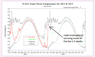
Something very interesting has happened in the last 1-2 weeks. It is called a "Stratospheric Warming Event" it is a very complicated process that I'm and still scratching my head at but basically it means a shift in the polar vortex. What is happening is the polar vortex is splitting and shift to another part of the Northern Hemisphere This will likely bring much colder air to the lower 48 in the next couple of weeks.
This could possibly create a double "Rex Block." 1 block off the coast of the western North America and the other over Greenland. Take a look at the image above of one operational forecast for February. The big globs of red are prolonged ridging of high pressure. This will then force all the cold air to pool and slide down into the lower 48 of the United States. The question is how close is the block to the Northstate? Too close and we'll be mild and dry, while the rest of the US freezes.
Lets take a look at a previous "Stratospheric Warming Event." In December of 1984 prior to the "Event" you can see the west was cold and the east was warm.
After the "Event" you'll notice how the Lower 48 was well below normal for the month of January in 1985.
Back to our weather. Next week we'll see the ridge developing off the coast and moving towards the Northstate. You can see the cold air starting to slide down from out of the Arctic, Canada and approaching the lower 48.
By next Friday the ridge is still over the Northstate and Rockies and east enter a deep freeze.
The MJO wave continue to strengthen this week. However, it is entering a dry, cooler phase for Northern California. You'll notice the forecast (yellow/green line) is moving into a Phase 5 and 6 in the near future.
Comparing the winter anamolies for a phase 5 and 6 shows a dry phase. The image above has all 8 phases. Look for phase 5 and 6 and map and you'll notice the brown over Northern California, which is drier than average.
Phase 5 and 6 are actually cooler phases for Northern California so we'll see how it interacts with the "Stratospheric Warming Event."
.gif)
.png)


