Thursday, November 29, 2012

High Impact Storm Today Through Sunday


Here is a look at the NWS in-house model for precipitation through the next 5 days.  Heavy totals showing up in Central, Northern Shasta County and another huge bullseye in East Butte, Western Plumas county.
Totals could approach 15-20+ inches in some of these locations.

In-house model showing the heavy rain stalling over the Northstate around 2:30 this afternoon


Heavy Rain still sitting still at 10:30 pm tonight.

At 1:30 am tomorrow morning heavy rain still training over the Northstate

3:00 am heavy rain not budging much


6:00 am heavy rain still in the Northstate

Finally by 9:00 am the rain begins to let up for the Northstate.

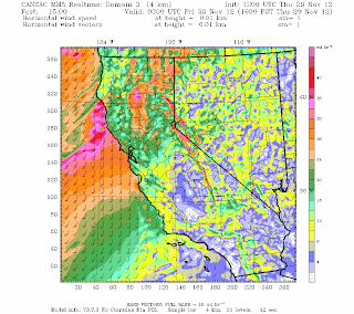
This image above is the forecast of 900mb winds at 1:00 am tomorrow morning.  That bullseye is in the Northern half of the valley floor.  900mb is about 3000ft in altitude.  So we have to do a reduction in the winds to the surface because of the friction of the earth.  The rule of thumb is 15%.  So if we were to take 73 knots which is about 84 mph and reduce is by about 15%, you're talking winds near 70 mph at the surface.  I think we will stay below that but something to keep a close eye on.


This wrf model shows very strong south winds but below 70mph winds.  However, with about 10 hours of heavy rain it is not going to take much to bring down trees in the highly saturated soils.

Next storm arrives late Friday night and it will be much weaker than today's.  Yet still bringing more unneeded rain to the Northstate.

The next powerful storm arrives Saturday evening and into the overnight period.  Expect another round of very heavy rain and high winds out of the south.

By Sunday afternoon the rain finally clears most of the Northstate.


Below is a list of several Sacramento River forecast near and around Red Bluff.  ORANGE LINE IS MODERATE STAGE.  RED LINE IS FLOOD STAGE.  BLUE LINE IS CURRENT.  GREEN AND PURPLE IS FORECAST RIVER HEIGHT.
River Forecast Page
Bend Bridge

Red Bluff

Vina Woodson Bridge


Tehama Bridge, Tehama


Monday, November 26, 2012

SIGNIFICANT RAIN EVENT THIS WEEK

As mentioned since last week we have some very heavy rain heading for the Northstate this week.  Model agreement continues to be high so this is shaping into a high confidence event 4- 5 days out.  A very strong trough will stall-out off shore, which will in turn tap into a very strong tropical moisture feed.  Several impulses of energy will rotate around the trough flinging moisture at the Northstate through next weekend.


Here's a quick look at the GFS 7 day total precipitation output through next Monday morning.  It is easy to see that the mountains locations could easily pick up over the 10+" of rain!  Even the valley is approaching over 6-7" in the northern half of the valley!

The Hydrometeorological Prediction Center only forecast total rain out to 5-days.  So through 4:00 am Saturday morning you can already see mountain locations seeing 7" based on their forecast.  This of course doesn't take into account Saturday and Sunday's rain too.


The image above is the hires simulated radar of the initial band/cold front slowly moving ashore.  This is valid at 4:00 am Wednesday morning.  This is actually a hair slower than some other models but it still gives you an idea of the rain coming in.


A wide view of the precipitation coming in and you can see the huge moisture feed going out nearly a 1,000 miles into the subtropics, feeding all the way into the Northstate.

This is the snow accumulation map.  This can only go out to 72 hours (through Thursday morning.)  You can see only the highest passes getting snow.  This will be a fairly warm event.  Also the lowest snow levels will likely be found Wednesday into Thursday (possibly down to 5,000ft) before snow levels rise even higher.


Strong south winds will also be a problem just like last week's storms.  With each front that comes in winds will increase out of the south.  We may see Wind Advisories issued and even some High Wind Warnings too for the higher passes.


Thursday, November 22, 2012

Very Active Pattern Next Week


Only a couple days removed from our last active pattern and we're already tracking the next.  We'll do a quick walk through of one operational forecast model (The American GFS) Starting next Wednesday night...


The image above shows the approaching initial cold front.  This is valid around 10:00 pm Wednesday night and the rain is starting slide into the folks to the west.


By 10:00 am Thursday morning the main precipitation shield has moved into the Northstate.  This initial wave of rain will bring high snow levels, likely around 7,000 ft.

Fast forward to 4:00 am Friday morning and another heavy line of rain is moving in and snow levels are dropping.  At this time snow levels around 5000 feetish

By 4:00 pm Friday snow levels continue to drop with very heavy precipitation continuing to funnel in


Continuing on to 4:00 am Saturday morning and this a very interesting output.  Very heavy precipitation with snow levels likely below 4000 ft.  So this could have major travel issues on several roadways
Finally a slight break in the action 4:00 am Saturday yet you can see more precipitation off to the north heading for the Northstate.

By 4:00 am the following Monday morning heavy precipitation moves in with snow levels back above 5000 ft.

By 4:00 pm more precipitation with snow levels back below 5000 ft

Even by 4:00 pm Tuesday still looking at scattered mountain snow showers. Snow levels around 4000ft


As always this is just one model run (quite the model run!!) so this is mainly to look for trends rather than exact timing and amounts.


Wednesday, November 14, 2012

Wet Pattern Begins Friday


      As mentioned in my blog post last Wednesday (blog post on signs of a wet pattern), several key oscillations and global teleconnection signals were pointing to a wet pattern for the Northstate.  It now appears that the wet and some what long duration pattern will begin early this coming Friday.

\
This is the current 5 day precipitation total from HPC, forecasted all the way through 4:00 am Monday morning.

You can see that they are currently going with around 2 inches for the valley and around 2-3 inches for the mountains, with a few isolated spots higher than that.

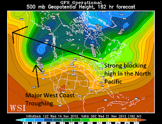
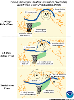
This is the current forecast Pacific North American (PNA forecast info) oscillation teleconnection.  As mentioned last Wednesday it is negative and looks to remain negative for the foreseeable future.  Typically a strong -PNA reading correlates with a strong blocking high in the North Pacific which allows for long term troughing on the West Coast.  With a trough close by that would increase our chances of wet and cold weather.


Currently the Arctic Oscilation (AO forecast info) is Positive but is forecast to soon to turn negative.  Typically a -AO corresponds to a weaker Polar Vortex which in turn allows for kinks or trough to swing further south into the lower 48.  In general, more troughs and more active weather for the lower 48.


Here is the overall pattern.  A typical -PNA setup.  Strong blocking high in the North Pacific allows for deep and powerful troughs to slide down to the West Coast.


Initial band of rain forecasted by our in house forecast model.  You can see rain moving up from the south around 1:30 am, early Friday morning.


By 10:00 am Friday morning heavier and more widespread rain now over the Northstate.

By 12:30 rain slowly starting to move into the foothills and higher elevations, mainly to the east.


By 4:00 pm you can see a heavy line of rain setting up over the valley floor on late Friday afternoon.


By 7:00 am Saturday morning rain still lingering over the Northstate, mainly the eastern valley, foothills and valley floor.


Still having timing issues, but appears our next strong and colder storm will arrive by 4:00 pm next Wednesday.


By 4:00 am Thanksgiving morning heavier rain moves into the Northstate.  Snow level look to be around 4000 ft


Even two weeks from today we continue to see the cycle of wet storms rotating through.  This is just a trend so do not plan any thing around these maps.


Wednesday, November 7, 2012

Signs Point to An Active Next Two Weeks

I have actually been holding back the last 3 days on this blog post waiting for a little reassurance before throwing down a long range forecast.

There are several forecast teleconnections/oscillations we look at besides the data that comes down from our very sophisticated numerical forecast weather models.

Here's what we're seeing....

This is the Madden Julian Oscillation Index.  In general it is a measure of Deep Tropical convection in the Indian Ocean that oscillates around the globe, later affecting the West Coast of N. America (primarily in the Late Fall and Winter months).  Over the last couple of weeks we have moved into a high amplitude 2/3 phase which later supports a wet pattern for Northern California.


You can see the high significance of a wet pattern for Northern California during active phase 2 and 3


A very simplistic animation of the MJO cycle


Another important blocking mechanism showing up on extended forecast models is a long and strong negative PNA (Pacific North American Teleconnection) phase.  Most models are keeping us negative through the next 16 days.

BOTH IMAGES ARE ANOMALIES FOUND IN NEGATIVE PNA PHASE DURING A 28 YEAR CLIMATOLOGY

There is high significance in a strong negative phase and cold/upper level lows from the Gulf of Alaska setting up over Northern California and the Pacific Northwest

With cold upper level lows in place this also supports cold surface temperatures too.


 MAPS BELOW ARE FROM THE 12z RUN OF THE 11-07-2012 GFS FORECAST MODEL RUN
Hints of our first strong cold front slowly moving in by day 10 (240 hrs out) next Saturday


 Very strong and wet low pressure system moving in by hr. 288 the following Monday
 Still wet through hr. 300
Even the very last frame (hr. 384), another extremely large wet and cold system moving towards Northern California.


Please do not takes these maps as exact forecast times and dates.  The important thing to see is the overall pattern and trend, not individual weather events.